1 Consider the following pairs :
River Famous Place
1. Mahanadi – Cuttack
2. Godavari – Kurnool
3. Narmada – Surat
4. Luni – Ajmer
How many of the above-given pairs are correctly matched ?
(a) Only one
(b) Only two
(c) Only three
(d) All four
Ans B
- Mahanadi River Basin Cities : Sambalpur, Raipur, Cuttack , Puri
- Krishna River Basin : Kurnool, Mahabubnagar , Anantapur , Bellary
- Tapi River: Surat
- Luni River: Ajmer
2 Consider the following pairs :
Drainage Patterns – Waterbodies
1. Centripetal – Rivers of Chotanagpur Plateau
2. Radial – Loktak Lake
3. Parallel – Rivers of Amarkantak Plateau
4. Dendritic – Rivers of Northern Plains
How many of the above-given pairs are correctly matched ?
(a) Only one
(b) Only two
(c) Only three
(d) All four
Ans A
Centripetal drainage patterns converge into a central depression. This pattern is formed by several streams that emerge from the surrounding uplands and converge in centrally low land, and it might be a depression, basin, or crater lake. Loktak Lake has a centripetal drainage system. All the major channels in the basin drain into the lake. So, Pair 1 is not correct.
When the rivers originate from a hill and flow in all directions, the drainage pattern is known as ‘radial’. The rivers originating from the Amarkantak range present a good example of it. It is also known as centrifugal pattern as it radiates in all the directions like thespokes of a wheel.
Parallel patterns are most commonly observed in areas with a steep slope or structural controls, It is a characteristic feature of ridge and valley topography. Many rivers taking their sources from the western flanks of Western Ghats drainwith straight courses towards west to empty into the Arabian Sea. This drainage pattern is not in Riversof Amarkantak Plateau. So, Pair 3 is not correct.
The drainage pattern resembling the branches of a tree is known as “dendritic” the examples of which are the rivers of northern plain. The dendritic pattern is the most frequent type of drainage. It is distinguished by the uneven branching of tributary streams in various directions at any angle, generally less than 90°. On homogeneous resistant rocks, dendritic patterns emerge, indicating a total absence of structural control. This pattern is more likely to be seen on roughly horizontal sedimentary rocks or in regions of large igneous rocks. They may also be observed in metamorphosed rocks. So, Pair 4 is correct.
3 Consider the following :
1. The river rises near Mhow in the Malwa Plateau.
2. Famous for Badlands Topography called Ravines
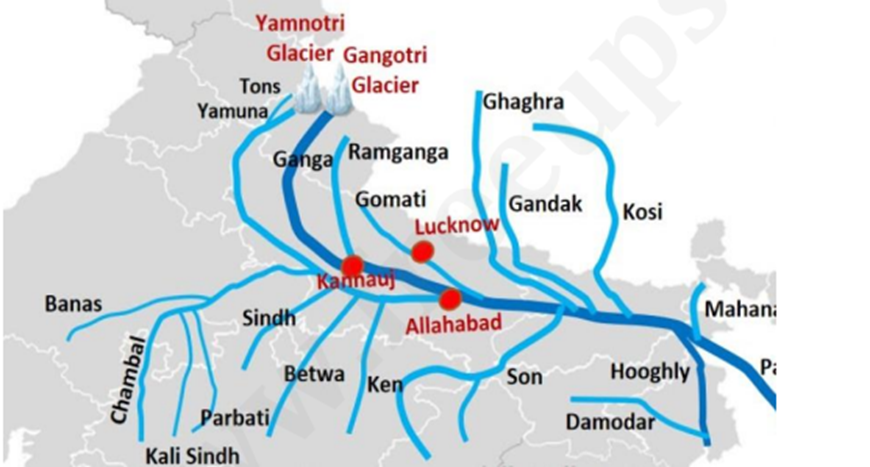
3. Kota barrage is constructed across this river
Which of the following rivers is described above ?
(a) River Luni
(b) River Chambal
(c) River Betwa
(d) River Rihand
Ans: B
Ans Chambal River: The Chambal is the chief tributary of the Yamuna River and rises in the Vindhy Range just south of Mhow which is located in malwa plateau western Madhya Pradesh state. The Kota Barrage is a crucial water management structure on the Chambal River, supporting irrigation, power generation, and tourism.
4 Which among the following is responsible for identifying the feasibility of river interlinking
projects ?
(a) National Water Development Agency
(b) Bureau of Water Use Efficiency
(c) Central Water Commission
(d) Namami Gange Programme
EXP
- Ans A
- The National Water Development Agency (NWDA) was set up on 17th July 1982 by the Government of India as a Society under the Societies Registration Act 1860 under the Ministry of Water Resources
- The NWDA is fully funded by the Government of India.
- Further, in 2006, the preparation of DPR of link projects and pre-feasibility/ feasibility reports of intra-basin links as proposed by States were also included in the functions of the NWDA Society. So, Option (a) is correct.
- Central Water Commission is a premier technical organization in India in the field of water resources and is presently functioning as an attached office of the Ministry of Jal Shakti, Department of Water Resources, River Development and Ganga Rejuvenation, and Government of India.
5 Consider the following :
1. Sikkim
2. Assam
3. West Bengal
4. Meghalaya
How many of the Indian states mentioned above does the River Teesta flow through ?
(a) Only one
(b) Only two
(c) Only three
(d) None
- Ans B
- Lifeline of Sikkim rises from TeestaKhangse glacier or Tso Lhamo LAke , North Sikkim near India China Border
- The River Teesta flows through Sikkim and West Bengal. It is a tributary of the Brahmaputra. The Teesta River originates from the Tso Lhamo Lake at an elevationof about 5,280 metres in north Sikkim.
- However, 83% of the river’s catchment area lies in India, and the remaining 17% is in Bangladesh, which supports 8.5% of its population and 14% of its crop production. So, Option (b) is correct.
6 How many of the following rivers have their origin in the Central Highlands ?
1. Luni
2. Mahi
3. Ken
4. Betwa
5. Wainganga
Select the correct answer using the codes given below :
(a) Only two
(b) Only three
(c) Only four
(d) All five
EXPLANATION:
- Ans D
- The Central Highlands of India is a vast plateau region between the Deccan plateau and the Indo- Gangetic plains,
- It comprises the states of Maharashtra, Madhya Pradesh, Telangana, Andhra Pradesh, Karnataka, and Tamil Nadu.
- It comprises several mountain ranges, plateaus, and valleys, including:
- Vindhya Range: An escarpment varying in character and height, depending on the underlying rock structure and lithology.
- Aravalli Range: Extends from Delhi southwest to near Ahmedabad for approximately 800 km.
- Malwa Plateau: A part of the Central Highlands, characterized by a rocky surface and dense forests to the east of the Chambal River.
- Bundelkhand Upland: Lies between the Yamuna and the northern arcuate scrap of the Vindhyan plateau.
- Narmada Valley: A valley carved out by the Narmada River, dividing the Central Highlands into North and South regions.
River Originatess From Central Highlands are :
- The Ken River is one of the major rivers of the Bundelkhand region of central India and flows through two states, Madhya Pradesh and Uttar Pradesh. It is a tributary of the Yamuna.
- Betwa River is a river in northern India that rises in the Vindhya Range just north of Hoshangabad, Madhya Pradesh. It flows generally northeast through Madhya Pradesh and Uttar Pradesh states and empties into the Yamuna River.
• Luni is the largest river system in Rajasthan, west of Aravali. It originates near Pushkar in two branches, i.e. the Saraswati and the Sabarmati, which join with each other at Govindgarh. From here, the river comes out of Aravali, known as Luni.
• Mahi River originates on the Northern slope of Vindhyas near the village of Sardarpur in the Dhar district of Madhya Pradesh.
• The Wainganga is a river in India originating in the Mahadeo Hills in Mundara near the village Gopalganj in Seoni, Madhya Pradesh. It is a key tributary of the Godavari. Wainganga is also part of the central highlands. So, Statements 1, 2, 3, 4 and 5 are correct.
7 Consider the following statements :
1. The Peninsula region mostly consists of relict and residual mountains.
2. The river valleys in the Peninsula block are shallow with low gradients.
3. The Sahyadri range forms the sharp edge of the Peninsular Plateau.
How many of the statements given above are correct ?
(a) Only one
(b) Only two
(c) All three
(d) None
EXP Ans C
8 . Consider the following rivers :
1. Kosi
2. Chenab
3. Satluj
4. Beas
Which of the rivers mentioned above is/are considered ‘antecedent’ ?
(a) 3 only
(b) 1 and 2 only
(c) 1 and 3 only
(d) 2 and 4 only
EXPLANATION:
- Ans C
- An antecedent river is a type of river that originated before the upliftment or folding of the land due to geological processes. These rivers maintain their original course and pattern despite changes in the underlying rock topography.
- Very deep gorges of the Indus, Satluj, Alaknanda, Gandak, Kosi and Brahmaputra rivers indicate their being antecedent rivers.
- The Kosi is an antecedent river with its source to the north of Mount Everest in Tibet, where its mainstream, Arun, rises. After crossing the Central Himalayas in Nepal, it is joined by the Son Kosi from the West and the Tamur Kosi from the East. It forms Sapt Kosi after uniting with the river Arun. So, Statement 1 is correct.
- The Chenab River and Beas are not considered an antecedent river.
- The Satluj originates in the ‘Raksas tal’ near Mansarovar at an altitude of 4,555 m in Tibet, where it is known as Langchen Khambab. It flows almost parallel to the Indus for about 400 km before entering India and comes out of a gorge at Rupar. It passes through the Shipki La on the Himalayan ranges and enters the Punjab plains. It is an antecedent river. It is a very important tributary as it feeds the canal system of the Bhakra Nangal project. So, Statement 3 is correct.
9 Consider the following statements :
1. It originates in the state of Himachal Pradesh.
2. It forms part of the southern boundary between Jammu & Kashmir and Punjab.
3. It joins the Chenab River after entering into Pakistan.
Which of the following rivers are described above ?
(a) Beas
(b) Jhelum
(c) Ravi
(d) Sutlej
- Ans C
- Ravi River Rises from Rohtang Pass, Kullu Hills, Himachal Pradesh , flows through Chamba Valley
- The Ravi River originates in the Lesser Himalayas and is the smallest river of all other transboundary rivers in India and Pakistan. In India, it is known as the river of Lahore. The total length of the Ravi River is 720 km in both India and Pakistan. It runs almost along the India-Pakistan border.
10 With reference to the Arunachal Himalayas, consider the following statements :
1. This region has the highest hydroelectric power potential in India.
2. The Shiwalik formations are absent in this part of the Himalayas.
3. Nanga Parbat and Kanchenjunga are important mountain peaks in this region.
Which of the statements given above is/are not correct ?
(a) 2 only
(b) 1 and 2 only
(c) 3 only
(d) 1 and 3 only
Ans B The Width of Shiwalik Formations is less in Arunachal Region. Statement 3 is incorrect .
11 With reference to the Godavari basin, consider the following statements :
1. The Godavari River rises from Trimbakeshwar in the Nashik district of Maharashtra.
2. The Godavari basin is present in six states only.
3. The Godavari basin receives maximum rainfall during the Southwest monsoon.
Which of the statements given above are correct ?
(a) 1 and 2 only
(b) 2 and 3 only
(c) 1 and 3 only
(d) 1, 2 and 3
- EXP:
- Ans C
- Statement 1 is correct
- The Godavari basin extends over the states of Maharashtra, Andhra Pradesh, Telangana, Chhattisgarh and Odisha, in addition to smaller parts in Madhya Pradesh, Karnataka and the Union territory of Puducherry. It flows for a length of about 1465 km before outfalling into the Bay of Bengal. So, Statement 2 is not correct.
- The Godavari basin receives its maximum rainfall during the Southwest monsoon.
- The largest tributary of the Godavari is the Pranhita,
- The Pravara, Manjira and Maner are right bank tributaries
- the Purna, Pranhita, Indravathi and Sabari are important left bank tributaries,
12 Consider the following :
1. Tapi
2. Subarnarekha
3. Sabarmati
4. Periyar
How many of the rivers mentioned above drain into the Arabian Sea ?
(a) Only one
(b) Only two
(c) Only three
(d) All four
Ans C
13 Consider the following statements :
Statement 1 : The West flowing rivers like Narmada and Tapti lack alluvial and deltaic deposits.
Statement 2 : The Narmada and Tapti rivers flow in trough faults and fill the original cracks with their detritus materials.
Which one of the following is correct in respect of the above statements ?
(a) Both Statement I and Statement II are correct, and Statement II is the correct explanation of Statement I.
(b) Both Statement I and Statement II are correct, but Statement II is not the correct explanation of Statement I.
(c) Statement I is correct, but Statement II is incorrect.
(d) Statement I is incorrect, but Statement II is correct.
Ans A
The Narmada and The Tapi flow in trough faults and fill the original cracks with their detritus materials. Hence, there is a lack of alluvial and deltaic deposits in these rivers.
14 Consider the following statements :
Statement I : The delta formation is usually absent in the rivers draining into the Arabian Sea.
Statement II : The course of the west-flowing rivers is comparatively shorter than the east-
flowing rivers.
Which one of the following is correct in respect of the above statements ?
(a) Both Statement-I and Statement-II are correct and Statement-II explains
Statement-I.
(b) Both Statement-I and Statement-II are correct, but Statement-II does not explain
Statement-I.
(c) Statement-I is correct, but Statement-II is incorrect.
(d) Statement-I is incorrect, but Statement-II is correct.
- Ans B
- While both statements are correct independently, Statement II does not provide an explanation for why delta formations are absent in west-flowing rivers. The absence of deltas is primarily due to geological factors rather than simply being related to river length.
15 Arrange the following rivers in the order of East to West using the codes given below :
1. Chambal
2. Ken
3. Betwa
4. Sindh
Codes :
(a) 3 -2- 4- 1
(b) 2- 3- 4- 1
(c) 1- 3- 4- 2
(d) 4 – 2 – 3 – 1
Ans B
16 . Which of the following rivers is a tributary of the river Brahmaputra ?
(a) Mahananda
(b) Kameng
(c) Sharada
(d) Barak
Ans b
17 Consider the following statements about landforms created by river systems:
1. Oxbow lakes are formed when a wide meander from the main stem of a river
is cut off to create a lake.
2. Alluvial fans are typically formed in the high gradient regions of mountain
fronts where rivers emerge from steep valleys onto flat plains
Which of the statements given above is/are correct?
(a) 1 only
(b) 2 only
(c) Both 1 and 2
(d) Neither 1 nor 2
Ans C
18 With reference to Indus River System, consider the following statements:
1. The Indus river originates from a glacier near Bokhar Chu in Kailash Mountain range.
2. The Chenab is the largest tributary of the Indus which is formed by the Chandra and Bhaga streams.
3. Indus is the westernmost of the Himalayan rivers in India.
Which of the statements given above is/are correct?
(a) 1 only
(b) 1 and 2 only
(c) 2 and 3 only
(d) 1, 2 and 3
Ans D
19 4 Consider the following statements:
Statement I: West-flowing peninsular rivers generally form estuaries rather than deltas.
Statement II: Peninsular rivers flowing through rift valleys have a steep descent into the sea.
Which one of the following is correct in respect of the above statements?
(a) Both Statement-I and Statement-II are correct and Statement-II is the correct explanation for Statement-I
(b) Both Statement-I and Statement-II are correct and Statement-II is not the correct explanation for Statement-I
(c) Statement-I is correct but Statement-II is incorrect
(d) Statement-I is incorrect but Statement- II is correct
Ans A
Statement I is correct: The west-flowing rivers of the Indian Peninsula, such as the Narmada and Tapi, typically form estuaries.
● Statement II is correct: Rivers like the Narmada and Tapi flow through rift valleys, leading to a relatively steep gradient as they approach the sea.
● Statement II is the correct explanation for Statement I: The steep gradient contributes to the faster flow of the rivers, preventing extensive sediment deposition that is necessary for delta formation. Instead, they are more prone to carve out estuaries where they meet the sea.
20 It is one of the longest rivers of India originating in Maharashtra and meets the sea in the Bay of Bengal in Andhra Pradesh. The River flows through the states of Maharashtra, Karnataka and Andhra Pradesh. The traditional source of the river is a spout from the mouth of a statue of a
cow. Rivers like Bhima, Warna, Musi, Dudhganga are one of the key tributaries
- Godavari
- Krishna
- Kaveri
- Tapi
Ans B
21 India’s Himalayan region is particularly vulnerable to Glacial lake outburst floods.
Which of the following is the most significant factor contributing to this vulnerability?
(a) Retreating glaciers forming numerous proglacial lakes
(b) Widespread deforestation leading to slope instability
(c) Predominance of bedrock dams with low structural integrity
(d) Intense monsoon rainfall patterns overwhelming natural drainage
Ans A
22 Consider the following pairs:
Hydroelectric Project : River
1. Nagarjuna Sagar Kaveri
2. Tehri : Bhagirathi
3. Indira-Sagar : Narmada
4. Idukki : Periyar
How many pairs given above are correctly matched?
(a) Only one pair
(b) Only two pairs
(c) Only three pairs
(d) All four pairs
Ans C
23 With reference to the Godavari river system, consider the following statements:
1. The Purna, Pranhita and Indravati rivers are its tributaries.
2. The Almatti Dam is built on the Godavari River.
3. It flows through Bhimashankar Wildlife Sanctuary.
How many statements given above are not correct?
(a) None of the statements
(b) Only one statement
(c) Only two statements
(d) All three statement
Ans C
Statement 3 is not correct: The Bhimashankar Wildlife Sanctuary is in the Western Ghats. Three rivers, Bhima, Ghod and Arala, originate from the western part of the Sanctuary. There are several streams meandering through its forests and the meadows that converge and flow as the Bhima River, which then spills into Krishna River, providing the waters and sediments to the Deccan plateau. Bhimashankar Sanctuary is famous for the highly endangered subspecies of the Indian Giant Squirrel Ratufa indica elphinstoni, locally known as Shekru. This is the state animal of Maharashtra. At the heart of the Sanctuary, there is an old shrine of Bheema Shankar, a Jyotirlinga of Shiva, at the origin of the River Bhima. The Sanctuary includes Semi-evergreen, Moist Deciduous and scrub forests.
24 . Consider the following pairs:
River : Source
1. Teesta : Tso Lhamo Lake
2. Alaknanda : Gaumukh Glacier
3. Son : Amarkantak Range
How many pairs given above are correctly
matched?
(a) Only one pair
(b) Only two pairs
(c) All three pairs
(d) None
Ans B
Pair 1 and 3 correct and Alaknanda rises from Satopanth glacier and Bhagiriti rises from Gaumukh Glacier.
25 Arrange the following Hill Ranges from North to South:
1. Nallamala Hills
2. Anaimalai Hills
3. Sechachalam Hills
4. Mahadeo Hills
Select the correct answer using the code given below:
(a) 4-3-2-1
(b) 3-4-1-2
(c) 4-1-3-2
(d) 3-4-2-1
Ans C
26 In the context of ‘slash and burn agriculture’, consider the following pairs:
Local Name for Slash & Burn Agriculture – Region
1. Kumari – Western Ghats
2. Khil- Himalayan Belt
3. Jhumming – North-eastern Region
How many of the above pairs are correctly matched?
(a) Only one
(b) Only two
(c) All three
(d) None
ANS C
27 Consider the following pairs:
Plateaus : Drained by
1. Chotanagpur : River Damodar
2. Bundelkhand : River Ken
3. Baghelkhand : River Son
How many of the pairs given above are correctly matched?
(a) Only one
(b) Only two
(c) All three
(d) None
- ANS A
- Pair 1 is correctly matched: The Chotanagpur plateau is the eastward extension of the peninsular plateau. It is drained by the Damodar River.
● Pair 2 is correctly matched: The Bundlekhand plateau covers the parts of northern Madhya Pradesh. It comprises the Vindhyan ranges. River Ken is a major river that drains the Bundelkhand plateau.
● Pair 3 is correctly matched: The Baghelkhand plateau lies in eastern Madhya Pradesh. It is drained by the rivers Tons and Son and their tributaries.
28 Which of the following statements is not correct with reference to the Peninsular
block of India?
(a) It has undergone block faulting processes.
(b) It is formed by a complex of very ancient gneisses and granites.
(c) It generally has deep river valleys with high gradients.
(d) Its northeastern part is separated from the Chotanagpur Plateau by the Malda fault.
Ans C
29 Consider the following statements:
1. The Khadar is a new alluvium deposited by the rivers along their course.
2. The Bhabar is a narrow belt of coarse gravel lying parallel to the Shiwaliks.
3. The Terai belt is a swampy area where the streams disappear.
4. Bhangar is the older alluvium lies above the floodplains of the rivers.
How many of the statements given above are correct?
(a) Only one
(b) Only two
(c) Only three
(d) All four
Ans C Statement 3 is incorrect
30 . Consider the following statements:
1. More than 90% of the Indian rivers are drained into the Bay of Bengal region.
2. Sahyadris act as a water divide between the Arabian Sea drainage and Bay of Bengal drainage.
3. In comparison to river basins, watershed regions are smaller.
How many of the statements given above are correct?
(a) Only one
(b) Only two
(c) All three
(d) None
Ans B
Statement 1 is Incorrect Nearly 77 % rives drain towards Bay of Bengal Region
31 The presence of the Peninsular Plateau is seen as far as in the northwestern part of
India, where it is covered by the crescent- shaped longitudinal sand ridges known as:
(a) Kayals
(b) Barchans
(c) Playas
(d) Parabolic dunes
Ans B Barchans are longitudinal sand ridges in the form of half-moon or crescent- shaped sand dunes.
32 Consider the following statements:
Statement -I: River Kosi is notorious for frequently changing its course.
Statement -II: River Kosi brings huge quantities of sediments from its upper reaches and deposits it in the plains.
Which one of the following is correct in respect of the above statements?
(a) Both Statement -I and Statement -II are correct and Statement -II is the correct explanation for Statement -I
(b) Both Statement -I and Statement -II are correct and Statement -II is not the correct explanation for Statement -I(c) Statement -I is correct but Statement- II is incorrect
(d) Statement -I is incorrect but Statement- II is correct
ANS A
The Kosi is an antecedent river with its source to the north of Mount Everest in Tibet, where its main stream Arun rises. After crossing the Central Himalayas in Nepal, it is joined by the Son Kosi from the West and the Tamur Kosi from the east. It forms Sapt Kosi after uniting with the river Arun.
The course of the Kosi River displays a strong meandering tendency and shifts their courses frequently. River Kosi, also known as the ‘sorrow of Bihar’, has been notorious for frequently changing its course. The Kosi brings a huge quantity of sediments from its upper reaches and deposits it in the plains. The huge amount of soil erosion at the river’s origin results in the huge amount of silt. The course gets blocked, and consequently, the river changes its course.
33 Consider the following pairs:
Dam-Reservoir : River
1. Mettur : Cauvery
2. Hirakud : Mahanadi
3. Jayakwadi : Godavari
4. Rana Pratap Sagar : Chambal
How many of the pairs given above are
correct?
(a) Only one
(b) Only two
(c) Only three
(d) All four
Ans D
34 Consider the following states:
1. Telangana
2. Tamil Nadu
3. Andhra Pradesh
4. Maharashtra
How many of the states listed above are part of the Krishna River Basin?
(a) Only one
(b) Only two
(c) Only three
(d) All four
Ans C
1, 3 and 4 are correct: Krishna river basin lies in the states of Karnataka (113,271 km2 ), Telangana, Andhra Pradesh (76,252 km2 ) and Maharashtra (69,425 km2 ).
35 Consider the following pairs :
Place Confluence of Rivers
1. Devprayag : Bhagirathi and Alak- nanda
2. Karna Prayag : Pindar and Alaknanda
3. Rudra Prayag : Mandakini and Alak- nanda
4. Joshimath : Dhauli and Vishnu Ganga
How many of the above pairs are correctly matched ?
(a) Only one
(b) Only two
(c) Only three
(d) All four
Ans d
36 Which of the following statements is not correct regarding the Western Ghats and
Eastern Ghats?
(a) The height of the Western Ghats generally decreases from north to south
(b) The highest peak of Western Ghats is Anai Mudi.
(c) The highest peak of Eastern Ghats is Mahendragiri.
(d) Eastern and the Western Ghats meet each other at the Nilgiri hills.
Ans A
37 Consider the following information :
River Place of Origin Tributary
1. Krishna – Mahabaleshwar in Sahyadri – Amravati
2. Kaveri – Brahmagiri hill in Karnataka – Bhima
3. Narmada- Amarkantak plateau – Dudhi, Tawa
In which of the above rows is the given information correctly matched?
(a) 1 and 2
(b) 1 only
(c) 3 only
(d) 1, 2 and 3
- Ans C
- Row 3 is correct : The Narmada originates on the western flank of the Amarkantak plateau at a height of about 1,057 m. Flowing in a rift valley between the Satpura in the south and the Vindhyan range in the north, it forms a picturesque gorge in marble rocks and Dhuandhar waterfall near Jabalpur. Its principal tributaries are the Burhner, the Halon, the Heran, the Banjar, the Dudhi, the Shakkar, the Tawa, the Barna ,the Kolar, the Ganjal, the Beda, the Goi, and the Orsang.
- Bhima is not a tributary of Kaveri river
- Amravati is not a tributary of Krishna river rather it is a tributary of Kaveri.
38 “This river rises in the Western Ghats and forms a boundary between two Southern States. The ancient name of the river was Pampa. It is a perennial river, but its flow reduces significantly during the summer.”
Which of the following rivers is described in the above passage?
(a) Kaveri
(b) Penna
(c) Bhima
(d) Tungabhadra
Ans D
39 Consider the following statements regarding Indian rivers:
1. Ponnaiyar River originates from the Nandi Hills with catchment areas located in Karnataka and Kerala.
2. Chenab river empties into the Jhelum river which is a tributary of the Indus river.
3. Sarayu river originates from Nanda Kot mountain in Nepal.
How many of the above statements are not correct?
(a) Only one
(b) Only two
(c) All three
(d) None
ANS C
- Statement 1 is not correct: Ponnaiyar River originates from the Nandi Hills in the Chikkaballapura district of Karnataka and flows through Tamil Nadu before emptying into the Bay of Bengal. It has a catchment area of 1,424 square miles and is located in Karnataka and Tamil Nadu states. (not Kerala)
- Statement 2 is not correct: Chenab after receiving the Jhelum River near Trimmu empties into the Sutlej River which is atributary of the Indus River.
- Statement 3 is not correct: Sarayu is a river that originates at a ridge south of Nanda Kot mountain in Bageshwar district in Uttarakhand, India
40 Arrange the major sources of water on Earth’s surface in descending order based on their contribution to the planet’s total water volume:
(a) Groundwater > Lakes > Soil Moisture > Streams and Rivers
(b) Groundwater > Glaciers > Freshwater Lakes > Biosphere
(c) Glaciers > Freshwater Lakes > Groundwater > Atmosphere
(d) Oceans > Glaciers > Groundwater > Freshwater Lakes
Ans A
41 Consider the following rivers:
1. Ganga
2. Cauvery
3. Godavari
Which of the following is the correct decreasing order of catchment area (in India) of the rivers given above?
(a) 1-2-3
(b) 1-3-2
(c) 3-1-2
(d) 3-2-1
Ans B
A catchment is an area of land where water collects when it rains, often bounded by hills. As the water flows over the landscape it finds its way into streams and down into the soil, eventually feeding the river. Some of this water stays underground and continues to slowly feed the river in times of low rainfall.
42 Grand Canyon of North America was created by which of the following rivers?
(a) River Mississipi
(b) River Missouri
(c) River Hudson
(d) River Colorado
Ans D
43 . Consider the following rivers:
1. Mandovi
2. Pamba
3. Brahmani
4. Subansiri
Which of the above rises from the Western Ghats?
(a) 1 and 2 only
(b) 2 and 4 only
(c) 3 and 4 only
(d) 1 and 3 only
Ans a
44 Shahpur Kandi barrage’ is situated on which of the following rivers?
(a) Ravi
(b) Jhelum
(c) Chenab
(d) Sutlej
Ans A
Shahpur Kandi Barrage-Shahpur Kandi barrage is situated on the Ravi River in the border of Punjab and Jammu and Kashmir. Hence option (a) is the correct answer.
45 . With reference to the Himalayan and the Peninsular Rivers, consider the following statements:
1. Himalayan rivers are perennial while Peninsular Rivers are seasonal in nature.
2. Peninsular rivers generally follow straight courses whereas in the Himalayan Rivers meandering by rivers is very prominent.
Which of the statements given above is/are correct?
(a) 1 only
(b) 2 only
(c) Both 1 and 2
(d) Neither 1 nor 2
Ans C
46 In India, the Tropic of Cancer passes through which of the following states?
1. Gujarat
2. Chhattisgarh
3. Tripura
4. Manipur
How many of the above options are correct?
(a) 1 and 4 only
(b) 2, 3 and 4 only
(c) 1, 2 and 3 only
(d) 1, 2, 3 and 4
ANS C
47 Consider the following:
1. Western Ghats
2. Himalaya
3. Sundarban
4. Indo Burma
5. Sundalannd
6. Terrai-Duar
How many of the above are the recognised biodiversity hotspots in India?
(a) Only three
(b) Only four
(c) Only five
(d) All six
Ans B
48 Consider the following statements regarding the Musi river:
1. It is a tributary to the Krishna iver.
2. Visakhapatnam is located on the bank of this river.
Which of the statements given above is/are correct?
(a) 1 only
(b) 2 only
(c) Both 1 and 2
(d) Neither 1 nor 2
ANS A The city of Hyderabad is located on the banks of this river. Hence statement 2 is not correct.• It was previously known as the Muchukunda River and originated in the Anantagiri Hills. • The Himayat Sagar and Osman Sagar dams are built on this river.
49 Consider the following statements with reference to a river:
1. It originates in the ‘Raksas tal’ near Mansarovar lake in Tibet.
2. It is an antecedent river.
3. It passes through the Shipki La pass.
Which one of the following rivers has been described by the above-given characteristics?
(a) Indus
(b) Satluj
(c) Beas
(d) Ravi
Ans B
50 Consider the following pairs:
Famous place River
1. Ujjain : Shipra
2. Ayodhya : Gomti
3. Srinagar : Jhelum
4. Madurai : Kaveri
How many pairs given above are not correctly matched?
(a) Only one
(b) Only two
(c) Only three
(d) All four
- ANs B
- Ayodhya is situated on the banks of the Sarayu River in the Indian state of Uttar Pradesh. (not on
- Gomti)
- The Sarda or Saryu river rises in the Milam glacier in the Nepal Himalayas where it is known as the Goriganga. Along the Indo-Nepal border, it is called Kali or Chauk, where it joins the Ghaghara(a major left-bank tributary of the Ganga River).
- Madurai Is situated on the Vaigai River
- Ujjain city situated on the eastern bank of the Shipra River, Ujjain was the most prominent city on the Malwa plateau of central India for much of its history.
- Srinagar lies in the Kashmir Valley along the banks of the Jhelum River, and the shores of Dal Lake and Anchar Lakes,
51 Consider the following pairs:
River Waterfall
1. Narmada : Dhuandhar
2. Subarnarekha : Hundru
3. Chambal : Chuliya
4. Mandovi : Dudhsagar
Which of the above given pairs are correctly
matched?
(a) 1 and 2 only
(b) 2 and 3 only
(c) 1, 3 and 4 only
(d) 1, 2, 3 and 4
Ans D
52 Consider the following statements:
1. Some rivers of the northern plain show a dendritic river pattern.
2. When the primary tributaries of rivers flow parallel to each other and secondary tributaries join them at right angles, the pattern is known as trellis river pattern.
Which of the statements given above is/are correct?
(a) 1 only
(b) 2 only
(c) Both 1 and 2
(d) Neither 1 nor 2
Ans C Rivers of the northern plain Show a Dendritic river pattern. The drainage pattern resembling the branches of a tree is known as “dendritic”. 1 is correct
When the primary tributaries of rivers flow parallel to each other and secondary tributaries join them at right angles, the pattern is known as ‘trellis’. Trellis drainage develops in folded topography where hard and soft rocks exist parallel to each other. E.g. The rivers in the upper part of the Himalayan region; Indus, Ganga and Brahmaputra. Hence statement 2 is correct.
53 Agra and Darjeeling, despite sharing the same latitude, exhibit notable differences in vegetation. Which of the following factors primarily determines this disparity in vegetation between the two regions?
(a) Distribution of Land and Water
(b) Distance from the Sea
(c) Different longitudes
(d) Altitude of the region
Ans D
54 With reference to River Satluj, consider the following statements:
1. The Satluj River originates near Mansarovar in Tibet and goes through Nathu LA pass in the Himalayas.
2. River Satluj feeds the canal system of the Bhakra Nangal project.
3. River Ravi meets the Satluj near Harike as the right bank tributary.
Which of the statements given above is/are
correct?
(a) 1 and 2 only
(b) 2 only
(c) 2 and 3 only
(d) 1, 2 and 3
Ans B
55 . The Gandhi Sagar dam is constructed on which river?
(a) Barakar
(b) Krishna
(c) Chambal
(d) Bhagirathi
Ans C
Maithon Dam is located in Jharkhand Constructed on the Barakar River (a tributary of Damodar
River)
Nagarjuna Sagar Dam is a masonry dam across the Krishna River at the border between Palnadu
district in Andhra Pradesh and Nalgonda district in Telangana.
The Gandhi Sagar Dam is one of the four major dams built on India’s Chambal River.
56 Consider the following peninsular rivers:
1. Vaigai
2. Sharavati
3. Vamsadhara
How many of the rivers given above flow from east to west?
(a) Only one
(b) Only two
(c) All three
(d) None
Ans A
57 With reference to river meanders, consider the following statements:
1. Meanders are the result of erosion and deposition both.
2. Meanders are developed through lateral erosion only.
3. Mature streams are more capable of forming meanders.
Which of the statements given above is/are correct?
(a) 1 only
(b) 1 and 3 only
(c) 2 and 3 only
(d) 1,2 and 3
Ans B
Meandering is most pronounced in the regions characterized by even surface and gentle slope,alluvial deposits and sufficient stream discharge.Mature streams are more capable of forming meanders because they resort to lateral erosion and consequently valley widening more than valley deepening.The Meanders are result of erosion and deposition both.Hence, statement 1 is correct.
1.Meanders developed through lateral erosion . Meanders developed by vertical erosion or valley deepening (incised meanders) .Hence, statement 2 is not correct.
Morphologically,river meanders are divided into 3 types viz. (1) wavy type of meanders, (2) horse-shoe type of meanders and (3) ox-bow or bracelet type of meanders
58 Consider the following pairs:
River Origin Tributary
1. Ghaghara : Mapchachungo : Rapti
2. Krishna : Trimbeksehwar : Musi
3. Mahanadi : Dandakaranya : Barakar
How many of the pairs given above are correctly matched?
(a) Only one
(b) Only two
(c) All three
(d) None
- ANS A
- The Ghaghara (also known as the Karnali in Nepal) originates from the Mapchachungo glacier in the Tibetan plateau, near Lake Mansarovar. Its important tributaries include Sarju, Rapti, Seti, Sarda, Bheri, Dahawar, Kuwana, etc. Hence pair 1 correctly matched.
- The Mahanadi River originates from dandakaranya in Chhattisgarh. The tributaries of Mahanadi include Seonath, Ib, Tel, Jonk, Mand, Hasdeo, etc. Hirakund dam and Talchir thermal power plant are located on the Mahanadi River. Hence pair 3 is not correctly matched.
- The Krishna River originates from north of Mahabaleshwar in the Satara district of Maharashtra. It does not originate from Trimbakeshwar, which is the origin of the Godavari River. The important tributaries of the Krishna Rivers are Ghatparbha, Malprabha, Tungabhadra, Sina, Koyna, Bima, Musi, etc. Hence pair 2 is not correctly matched.
59 This dam is the fourth oldest water-regulator structure in the world and the oldest in India that is still in use. It was built by Karikala king of the Chola Dynasty in 150CE. It was built across the Cauvery River in the Thanjavur district of Tamil Nadu. The above passage describes which of the following dams:
(a) Krishna Raja Sagara Dam
(b) Idduki Dam
(c) Kallanai Dam
(d) Mettur Dam
Ans C
- Kallanai Dam (also known as Grand Anicut) is one of the oldest water-regulator structures in the world and the oldest in India that is still in use today. It is located on the Cauvery River in the Thanjavur district of Tamil Nadu.
- Somasila Dam located on the Pennar River in Andhra Pradesh, was built in modern time.
- Idukki Dam is a hydroelectric dam in Kerala across the Periyar River and was built in the 20th century.
- Mettur Dam was built on the Cauvery River in the early 20th century (1934) and is there for not
- ancient or related to the Chola dynasty.
60 . Consider the following statements regarding the Luni River:
1. It is saline in nature because of excessive limestone at its place of origin
2. It makes a saline estuary when falls in theGulf of Khambhat
Which of the statements given above is/are correct?
(a) 1 only
(b) 2 only
(c) 1 and 2 both
(d) Neither 1 nor 2
Ans D
61 Which of the following article of Indian Constitution is related with Inter state river .
- Article 148
- Article 263
- Article 262
- Article 280
62The famous Virupaksha temple and Hampi UNESCO World Heritage site is located on the bank of which river
- Bhima
- Tungabhadra
- Krishna
- kaveri
63 Which of the following State is called as ” Hexadeltic Region of India “
- Maharastra
- Gujarat
- Odisha
- Kerala
64 With reference to Peninsular rivers and their places of origin, consider the following pairs :
RIVERS PLACE OF ORIGIN
1. Krishna – Bastar Plateau
2. Kaveri – Brahmagiri Hills
3. Mahanadi – Amarkantak Plateau
4. Godavari – Satpura Range
How many of the pairs given above are correctly matched ?
- Only One
- Only two
- Only three
- All Four
Ans A
65 Which of the following States related with Catchment area of Krishna River Basin ?
1. Maharashtra
2 Karnataka
3 Odisha
4 Andhra pradesh and Telangana
5 Tamilnadu
Select the Correct Code :
- 1, 3 and 5
- 1, 2 and 4
- 1, 3 and 4
- 1, ,2 and 3
Ans B
66 Which of the following is tributary of Krishna River System :
1. Musi
2 . Bhima
3 Koyna and Panchganga
4 Ghatprabha and Malaprabha
Select the Correct Code:
- 2 and 3 only
- 1, 2 and 4
- 1 and 3 only
- 1, 2, ,3 and 4
Ans d
67 The second biggest waterfall in India known as Shivasamudram Falls , located on Which River System?
- Krishna
- Kaveri
- Godavari
- Sharavati
Ans b
68 . Consider the Statements with respect to ” Kaveri river system”
1. The Origin of Kaveri river from Niligiri Hills .
2. The drianage basin of Kaveri includes only three States and one Union Territory
3. Noyyal, Bhavani, Shimsha , Kabani are key tributaries of this river system
How many of the statements are True?
- One Only
- Two Only
- All
- None
Ans B
69 The Tributaries ” Dhansiri , Dikhow, Kopili , Kameng” related with
- Barak
- Brahmaputra
- Mahanadi
- Damodar
70 Which of the following River Cuts Tropic of Cancer Twice in India ?
- Narmada
- Tapi
- Mahi
- Chambal
71 Which of the following is the correct Course of River Mahi from emerging State to merging State at Coastal Region .
- Madhya Pradesh- Gujarat- Maharashtra
- Maharashtra- Madhya Pradesh- Gujarat
- Madhya Pradesh – Rajasthan- Gujarat
- Rajasthan- Gujarat – Maharastra
Ans C
72 Which of the following River Originates from Vindhya Range
1. Mahi
2 Banas
3 Son
Select the Correct Code :
- 1 only
- 2 and 3
- 1, 2 and 3
- None
Ans A
EXP Mahi River
- The total length of Mahi is 583 km.
- It originates from the northern slopes of Vindhyas, Dhar district of Madhya Pradesh,
- It extends over the states of Madhya Pradesh, Rajasthan, and Gujarat,
- It then enters the south eastern portion of Rajasthan, which is the Vagad region. The river flows through the Banswara district, which comes under the Vagad region.
- Before entering Gujarat, the river makes a ‘U’-shaped loop in Rajasthan.
- it drains into the Arabian Seathrough the Gulf of Khambhat.
- The Mahi River has a dam on it, namely, the Banswara dam or Mahi Bajaj Sagar Dam. The whole of Gujarat gets water to drink and electricity from the dam.
- The main tributaries of the river are Eru, Nori, Chap, Som, Jakham, Moran, Anas, Panam, and Bhadar.
73 Consider the statements with respect to Peninsular Rivers System
1. They are Older than Himalayan Rivers and having broad shallow Valleys.
2. These Rivers can make Delta, Estuaries .
3 They are characterised by fixed course, absence of meanders and non perennial flow of rivers .
4. Some Peninsular Rivers Part of Himalayan River System .
How many of the Statements are Correct ?
- one only
- two only
- three only
- All of the above
Ans D
74 Which of the following Rivers Not Rises From Vindhya Range
- Chambal
- Betwa
- Ken
- Son
Ans D
Son River Rises from Amarkantak Region Part of Maikal Range, Satpura Mountains
75 Consider the Statements
1. Several tributaries of the Ganga-Yamuna system originate from the Vindhyas.
2 Narmada and Son rivers drain the southern slopes of the Vindhyas.
3 Narmada and Son rises from Maikal Hills, Part of Satpura Range
4 Narmada and Son Cuts Tropic of Cancer
How many of the Statements are Correct ?
- one only
- two only
- three only
- All of the above
Ans C
76 Aaliya Bet Island is situated in Gujarat is surrounded by
- River Tapi
- River Narmada
- River Sabarmati
- River Mahi
Ans B
Aliabet island is located in Gujarat and it is basically a river island in the delta of River Narmada. It is situated near the Gulf of Khambhat.
77 With reference to geography of India, Pangong Tso and Tso Moriri are related
to:
(a) Mountain Peaks
(b) Fresh water Lake
(c) Mountain Range
(d) Salt Water Lake
Ans d
78 Consider the following Rivers:
1. Subarnarekha
2. Vamsadhara
3. Sharavati
4. Mandovi
Which of the above rivers flowing towards the East?
(a) 1 and 3 only (b) 2 and 4 only
(c) 1 and 2 only (d) 3 and 4 only
Ans C
79 Which one of the following areas is most affected by soil erosion in India?
(a) Malwa plateau
(b) Terai area of Uttar Pradesh
(c) Coastal area of Andhra Pradesh
(d) Chambal valley
Ans. (d) The Chambal valley is one of the most affected areas by soil erosion in India. The Chambal river is a major tributary of the Yamuna river and flows through the States of Madhya Pradesh, Rajasthan, and Uttar Pradesh. The river basin is characterised by hilly terrain, soft sedimentary rocks and a semi-arid climate. These factors make the region susceptible to soil erosion
80 Which of the following Rives Emerges From Chota Nagpur Plateau Region:
1. Subarnarekha River
2 Damodar River
3 Rihand and North Koel River
4 Barakar River
Select the Correct Code:
- 1 and 4
- 1 and 3
- 2 and 3,4
- 1,2,3 and 4
Ans D
81 Assertion and Reasoning
Assertion (A): Ganga plain is the most densely populated part of India.
Reason (R): Ganga is the most harnessed river of India.
a) Both A and R are true and R is the correct explanation of A
b) Both A and R are true but R is not a correct explanation of A
c) A is true but R is false
d) A is false but R is true
Answer: b) Both A and R are true but R is not a correct explanation of A
82 Assertion and Reasoning
Assertion (A): River Kalinadi is an east-flowing river in the southern part of India.
Reason (R): The Deccan Plateau is higher along its western edge and gently slopes towards the Bay of Bengal in the east.
a) Both A and R are true and R is the correct explanation of A
b) Both A and R are true but R is not a correct explanation of A
c) A is true but R is false
d) A is false but R is true
Kaalinadi • The Kali River, also known as Kaalinadi, flows through the Uttara Kannada district of Karnataka. • The river, spanning 184 kilometers, rises in the Western Ghats and flows into the Arabian Sea
Answer: d) A is false but R is true
83 Consider the map given below:
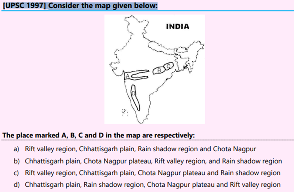
Ans C
84 Which of the following river originates in the Western Ghats and flows westward?
(a) Bhima
(b) Tungabhadra
(c) Kaveri
(d) Periyar
Ans – (d)
Explanation – the river Periyar originates in the Western Ghats and flows towards the west.
85 Sometimes in the News , Parbati , Gambhir , kali Sind, are associated with
- Mangroves Region
- Saline Lakes
- Fresh Water lakes
- Small Rivers
86 River Brahmaputra is called YarlungTsangpo in Tibet . It Emerges From 4877 M Altitude from Which of the following location in the Tibet Autonomous Region (TAR).
- North East of Tibet
- South East of Tibet
- North West of Tibet
- South West of Tibet
Ans D
87 Which of the following river not originates from Bhutan ?
- Manas
- Raidak
- Sankosh
- Kopili
Ans d
88: The Barak River flows through :
1. Assam
2 Manipur
3 Nagaland
Select the correct code:
- 1 and 2
- 2 and 3
- 1,2 and 3
- None
Ans C
Barak River flows through the states of Manipur, Nagaland, Mizoram, and Assam in India and into the Bay of Bengal
89 Consider the following rivers:
- Barak
- Lohit
- Subansiri
Which of the above flows/flow through Arunachal Pradesh?
- 1 only
- 2 and 3 only
- 1 and 3 only
- 1, 2 and 3
Answer: (b) 2 and 3 only
90 India and Bangladesh share many rivers, creating one the World’s best delta by the confluence of many rivers .
In this context, consider the following statements :
1. River Brahmaputra and River Tista confluence is known as Jamuna river .
2 River Jamuna and River Ganga confluence known and Padma River
3. River Padma and river Barak known as the Meghna river
Select the correct code :
- 1,2 and 3
- 2 only
- 1 and 3
- None
Ans
- Only statement 2 is corrrect .
- Padma is distributary of Ganga, flow south east and meet with Meghna to become Lower Meghna river.
- Upper Meghna formed in Bangladesh by Joining of Surma and Kushiyara ( both part of Barak)
Padma is major tributary of Meghna
91 Where does the Barak River originate?
a) Himalayas
b) Manipur Hills
c) Khasi Hills
d) Jaintia Hills
Answer: b) Manipur Hills
92 The Brahmaputra plains is charactierised by Humid climate with high temperature throughout the year . Which one among the following pairs of crops is most suitable for this region ?
- Pineapple and cotton
- Wheat and Jute
- Paddy and Jute
- Cotton and Wheat
93 Consider the following Pairs :
(River ) (Origin )
1 Burhi Dihang : Patkai Bum
2 Dhansiri : Naga Hills
3 Kapili: Jaintia Hills
Select the Correct Code :
- 2 and 3
- 1 and 3
- 1, 2 and 3
- 1 only
Ans c
94 Which one of the following is the correct North to South sequence of the Northern Plains of India.
- Tarai – Bhabar – Bhangar – Khadar
- Bhabar – Tarai- Khadar – Bhangar
- Bhangar- Khadar – Terai – Bhabar
- Bhabar – Terai – Bhangar -Khadar
Ans D
95 The lower Gangetic plain is characterised by humid climate with high temperature throughout the year. Which one among the following pairs of crops is most suitable for this region?
(a) Paddy and cotton
(b) Wheat and Jute
(c) Paddy and Jute
(d) Wheat and cotton
AnsC
96 Punjab Plain is also called the ‘Land of Five Rivers’. The Punjab part of this plain is primarily made up of the 5 ‘Doabs’ (tract of land lying between two confluent rivers),
Which of the following is most eastern most Doab
- Bist Doab
- Bari Doab
- Rachna Doab
- Chaj Doab
Ans A
97 Consider the Pairs
1. Bet Lands: These are Khadar-rich floodplains, wherein fertile soils are deposited annually, making them very fertile.
2 Dhayas: These are broad flood plains of Khadar flanked by bluffs.
3 Chos: The northern part of this plain adjoining the Shiwalik hills has been heavily eroded by numerous streams, which are called Chhos.
Which of the following is correct ?
- 1 only
- 2 and 3
- 1,2 and 3
- None
Ans C
98 Salinization occurs when the irrigation water accumulated in the soil evaporates, leaving behind salts and minerals. What are the effects of salinization on the irrigated land?
(a.) It greatly increases the crop production
(b.) It makes some soils impermeable
(c.) It raises the water table
(d.) It fills the air spaces in the soil with water
Solution (b)
99 The Koraput Region is key region of Traditional Agriculture in India according to Food and Agriculture Organisation (FAO) and Also The Region called As” Switzerland of That State”. The Above Context related with which of the following State of India ?
- Madhya Pradesh
- West Bengal
- Odisha
- Tamilnadu
Ans C
Koraput district is a district of India in southern Odisha, with headquarters at Koraput. The district is located in the Eastern Ghats and is known for its hilly terrain, rich and diverse types of mineral deposits and its tribal culture and traditions.
100 Consider the Passage :
The River formed by the confluence of the Namphuk and the Namchik, which rises from the Patkai ranges . The plains of this sub-basin are very fertile. Almost the entire high land is covered by Tea gardens. The River has created number of oxbow lakes in the area.
The above passage related with which of the following River ?
- Manas
- Torsa
- Raidak
- Burhidehing
Ans Dihing or Burhi Dihing rise from Patkai Hills in Arunachal Pradesh . and flows through Tinsukia and Dibrugarh Districts in Assam to its confluence with the Brahmaputra at Dihingmukh. Namdapha river is a tributary of the Dihing on its northern bank. The Betel nuts are produced most in the areas of the Dihing Plains
Recent Comments